Earthquakes & Seismic Activity in Egypt
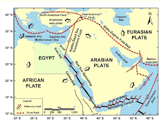
The start time of the recording of earthquakes in Egypt started as early as 1899, along with studying the seismicity of the country. The seismicity research and studies in Egypt were an attempt for diving Egypt into active seismic source and evaluation zone. These seismic source zones can be used for constructing the seismic hazard map based on the seismotectonic of the region. The newly dense broadband digital seismographs in Egypt and the surrounding regions produce a high quality waveform data. This has widely made a considerable progress in the study of the physics of local earthquakes in Egypt and the precise determination of their locations. This has enabled to understand the interrelationship between the geological structure and the recent seismicity. Emphasizing that there are several focal solution studies for earthquakes that have occurred in Egypt, based on the polarity of the first motion of P-wave.
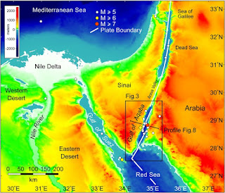
The strongest earthquake in Egypt happened on 11/22/1995 in the region Nuwaybi; Saudi Arabia; Israel; Jordan with a magnitude of 7.2 on the Richter scale. The shifting of tectonic plates in a depth of 11 km resulted in 12 deaths. The earthquake also triggered a tsunami with further victims and destructions. While the second biggest quake that was described as the strongest ever recorded until 1992 near the Egyptian capital, struck at 3:10 P.M. and lasted 20 seconds. It registered 5.9 on the Richter scale, a gauge of the energy released by an earthquake as measured by ground motion.
In general, buildings in Egypt are not designed to resist earthquakes, therefore relatively small events can be the source of huge socio-economic disasters. The event of 1992 October 12 is an example of a small but damaging earthquake in Egypt. This event, of magnitude mb = 5.4, resulted in 554 people being killed, about 20 000 people being injured and over one billion US$ reported as property losses. This was not the only destructive earthquake in Egypt: similar events occurred in the years of 778, 1303 and 1847. These earthquakes destroyed parts of big cities such as Cairo and Alexandria.
The economic and social effects of earthquake disasters can be reduced through a comprehensive assessment of seismic hazard and risk for areas such as Egypt. Such a study leads to an increased public awareness, with a consequent upgrading of the existing buildings and engineering works as well as reliable earthquake-resistant designs for new structures.
FACT!!!!! The pyramid shaped building is suitable in earthquake prone area due to its higher stiffness & less displacement.
Resources:
Abdelazim, M., Samir, A., El-Nader, I. A., Badawy, A., & Hussein, H. (2016, August 27). Seismicity and focal mechanisms of earthquakes in Egypt from 2004 to 2011. NRIAG Journal of Astronomy and Geophysics. Retrieved September 7, 2022, from https://www.sciencedirect.com/science/article/pii/S2090997716300293#:~:text=Egypt%20is%20a%20region%20of,African%2C%20Arabian%20and%20Eurasian%20plates.
El-Sayed, A., Vaccari, F., & Panza, G. F. (2001, March 1). Deterministic seismic hazard in Egypt. OUP Academic. Retrieved September 7, 2022, from https://academic.oup.com/gji/article/144/3/555/613540
IRJET-Archives (2014-2021). (n.d.). Retrieved September 8, 2022, from https://www.irjet.net/archive
Latest earthquakes. (n.d.). Retrieved September 7, 2022, from https://earthquake.usgs.gov/earthquakes/map/?extent=58.7682%2C-45.79102


Hello Charbel,
ReplyDeleteI am very impressed with your work! lots of information that you covered in your piece. I am in the same boat with my country and its seismic activity. Moreover, there is not a lot activity in your country. Nice work!
Very good seismic reflection!- very cool info about pyramids!
ReplyDeleteHello Charbel,
ReplyDeletereading your blog and noticing that earthquakes can cause significant damage to your country is sad. Many buildings are not strong or built enough for these type of hazards.