Coastal Hazards in Egypt!
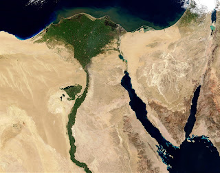
Egypt’s Nile Delta and its coastal front on the Mediterranean are considered vulnerable to shoreline changes due to erosion and accretion, subsidence and sea level rise due to climate change. Heavy rains often result in flash floods in Egypt. Rain-induced floods wash away property, claim lives and displaced people. Dust storms are also common in Egypt, frequently spanning hundreds of kilometers.
Climate change is now recognized to have a significant impact on disaster management efforts and pose a significant threat to the efforts to meet the growing needs of the most vulnerable populations. The demands of disaster risk management are such that concise, clear, and reliable information is crucial!

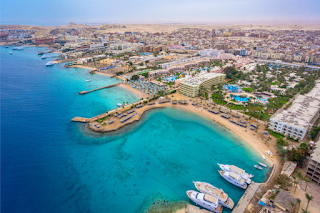
When we research we notice that the arid North African coasts of Egypt, with a total population of more than 19 M, show very high vulnerability risk scores of 71%, extending along hundreds of kilometers of coastline that makes Egypt coastal area the largest vulnerability zones in the central and eastern Mediterranean Basin.

As a result we can conclude that Egypt’s key vulnerabilities are a combination of:
- Heavy rains often result in flash floods in Egypt. Rain-induced floods wash away property, claim lives and displaced people.
- An increase in the maximum amount of rainfall in any 5-day period (a surrogate for an extreme storm event) is projected to increase and the maximum period between rainy days is expected to decrease, which will inevitably result in greater flooding and storm damage.
- While sandstorm occurrences have decreased since the 1960’s, climate change is likely to increase the frequency of sand and dust storms. The Khamsin weather that causes dust storms is associated with a desert depression following extreme temperature rises, and causes loss of top soil and often results in respiratory complications.
While the implications for digital rights management would be:
- Saline sea water will penetrate far into the northern delta, turning the current lakes into shallow saline lagoons and bays.
- Inundation along coastal areas due to sea level rise leading to destruction of property and disruption of the proper functioning of infrastructure facilities directly exposed to the sea.
- Substantial reduction in agricultural productivity.

The SLR scenarios for example made a scenario of Egypt Flood that may take place in the year 2100 as “the Global mean sea level is projected to rise by 2m at the end of this century. However, in order to determine local sea level rise (SLR), one has to take into account local coastal flood levels which could be 2.8m above Mean Higher-High Water (MHHW) at extreme forecasts. These local levels bring variability to the projected SLR from 1m to 6.5m” (Earth.org)

Resources:
Hzami, A., Amrouni, O., & Abdeljaouad, S. (2021, January 27). Alarming coastal vulnerability of the deltaic and sandy beaches of North Africa. Nature News. Retrieved November 16, 2022, from https://www.nature.com/articles/s41598-020-77926-x#Sec18
Mulhern, O. (2020, October 9). Sea level rise projection map - alexandria. Earth.Org. Retrieved November 16, 2022, from https://earth.org/data_visualization/sea-level-rise-by-the-end-of-the-century-alexandria/
World Bank Climate Change Knowledge Portal. Vulnerability | Climate Change Knowledge Portal. (n.d.). Retrieved November 16, 2022, from https://climateknowledgeportal.worldbank.org/country/egypt/vulnerability#:~:text=Egypt's%20Nile%20Delta%20and%20its,in%20flash%20floods%20in%20Egypt.
Hey Egypt! I thought you knocked this one out of the park! You were very thorough with your information and I loved how many visuals you included. I didn't know that flash floods could worsen the shoreline! Overall great blog this week!
ReplyDelete